Posts

Showing posts from April, 2023

Snow!

I'm in Colorado Springs, but Mike reports that in the last two days, we've gotten 11 inches of snow at our house.  This puts us just 1.5 inches short of 15 FEET for the year.  Whoa. 

Pothole Man

Image
 About 10 years ago, a now-former neighbor abruptly decided she would no longer let me drive her anywhere.  The words were never spoken, but I assumed she thought my driving was dangerous.  I asked Mike if there was anything about my driving that bothered him, expecting him to comment perhaps on hugging the center line, driving too fast, tailgating, but no.  He was bothered only by my not looking out for potholes.  He is now on pothole watch and has already been down to the bridge over the ice park to fill in holes.  Camp Bird Road is getting bad, and he's started working on the holes on MFL I got my first hike under my belt yesterday when I went on the Perimeter Trail from the Visitors Center to Cascade Falls.  I didn't know how much I really needed it.  There was only a small patch of ice, maybe two feet long and a foot wide on one section; otherwise, it was all clear.   Love those ice pillars The Ouray Trail Group started working Monday on the revised section of the Perimete

A picture

Image
I drove up to Angel Creek Campground to see what the melt was looking like.  Camp Bird Road is still closed above there because of dangerous avalanche conditions.  The melt is ramping up, for sure, but it's not where it's going to be.   MFL and Camp Bird Road are clear, nasty potholes forming, but still driveable.

Mud season

Image
Mike and I walked in Ridgway State Park today.  It's still difficult walking in the neighborhood, although getting better.  I read the day before yesterday that state water managers are already executing plans to avoid flooding during the massive snowmelt to come.  We saw that for ourselves because Ridgway reservoir is being drained a lot in preparation for that. You'll see on this map that Ouray is in the Gunnison drainage but very close to the San Miguel etc. drainage.  I'm surprised that those two have higher percentages than the Yampa and White because the snow totals in Steamboat Springs have been outrageous.  I guess Crested Butte and environs were outrageous enough to bump us up. JP (20) called me last week concerned about what he was seeing on his outdoor cameras.  Mike and I walked over and discovered that a huge slab of snow/ice had slid off the roof and taken out a small section of the deck railing.   Barb (3) texted me yesterday that their Starlink antenna came

That time of year

Image
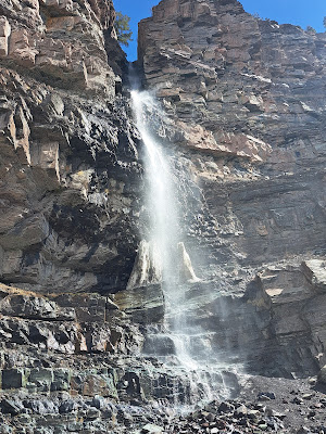
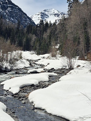
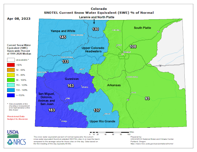
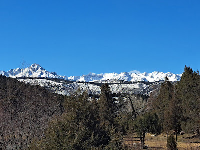
 It's 53 degrees today, 54 degrees yesterday, and the melt is on...until Tuesday when the bottom falls out, highs in the 20s, lows in single digits through Wednesday.  Then it bumps back up!  If we want to walk anywhere longer than about a block, we have to go to Ridgway or Montrose.  The Ice Park closes today after what seemed to me to be a spectacular year, both parking lots full most of January, February, and March. Lots of snow! Anyone we talk to comments on the difficult winter.  The road sign as we turn onto Camp Bird Road changed yesterday from a warning not to go above Angel Creek Campground to road closed at Angel Creek because of extreme avalanche danger.  We drove over to Silverton last Wednesday, and the aftermath of many avalanches can still be seen from the road.  The avalanche shed just above us on 550 is a good example of a major avalanche happening, so big that it fell over onto the south side of the highway and blocked the road.  We couldn't see the river at t